The extra information has provided a huge leap forward in computer vision capabilities and is used to more accurately identify specific objects and land cover classes of interest.
The application of Deep Learning (DL) to analyse satellite imagery is paving the way for the Earth Observation field to reinvent itself.
This can extend the reach through novel idea-thinking to solve new challenges and optimise traditional ways of monitoring and mapping.
Thanks to the exponential growth of active satellites together with advancements in Big Data and Cloud Computing, information from space is becoming more accessible.
This allows for enormous quantities of data to be stored and analysed at a much faster pace.
At DHI GRAS mapping of specific features of interest and land cover is a key service delivery. We are experts in extracting information from satellite imagery to meet our client’s needs.
A common approach has been to train classical machine learning algorithms (e.g. Support Vector Machine or Random Forest) to label each pixel in a satellite image.
However, one of the shortcomings of this approach is that each pixel in the image is classified independently of its neighbouring pixels – meaning the spatial context in imagery is not considered.
The main advantage of Deep Learning algorithms is that they can recognize patterns, shape, and context in imagery, and use this to better map different objects of interest.
By doing so, they use not only the spectral information from pixels, but also the surrounding spatial information that is associated with objects.
Land Cover Mapping
Our Deep Learning Lab has seen significant improvements in land cover mapping using latest DL algorithms for image segmentation.
For large area mapping we take advantage of imagery provided by the European Space Agency’s Sentinel satellites. These satellites deliver state-of-the art optical and radar imagery free of charge for the entire globe – which have revolutionized mapping capabilities since they were launched in 2015.
Using this imagery in combination with Deep Learning has greatly improved our capabilities in mapping specific land cover or land use types including water & wetlands, crop-types, irrigated areas, forests and many more.
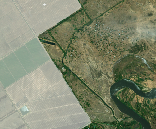
Mapping of irrigated cropland in Malawi using Convolutional Neural Networks (CNN) and Semantic Segmentation.
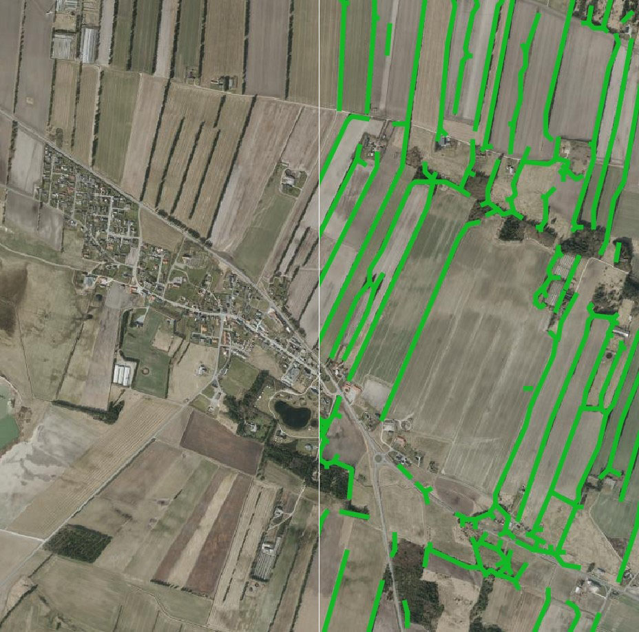
Mapping ‘wind breaks’ in open landscapes using Deep Neural Networks. Satellite imagery (left), predicted windbreaks (green outline) from the Deep Neural Network (right).
Mapping wind breaks in open landscapes
One of the latest innovations we have been working on is mapping ‘wind breaks’ in open landscapes, relevant for the wind power industry. Wind breaks are barriers such as tall fences, walls and hedges located throughout the landscape which can increase the surface roughness and drag, and decrease the expected wind flow. Information on the location of windbreaks is therefore important when making wind flow models and planning the location of wind turbines.
Interestingly, this DL network was originally designed for biomedical image segmentation, however it has proved highly useful when applied to satellite imagery. We trained and validated the model on Sentinel-2 imagery using a sample of known wind breaks throughout Denmark, with impressive results. Once identified, these wind breaks can then be used for better estimation of surface roughness.
Object Detection
We have also had much success with using DL for object detection and recognition in satellite and aerial images. We have found that many of the DL models used in other fields such as biomedical imaging and self-driving cars, work equally well on satellite images, with little adaptation.
Furthermore, we have been able to use transfer learning, to leverage models pre-trained on more general image datasets, . This is great news, since it enables us to get good results with comparatively little training data.
In short, this means that we can detect objects such as cars, solar panels, swimming pools, etc. with high accuracy and short turnaround for delivery, while only requiring a small amount of training data even for larger areas.
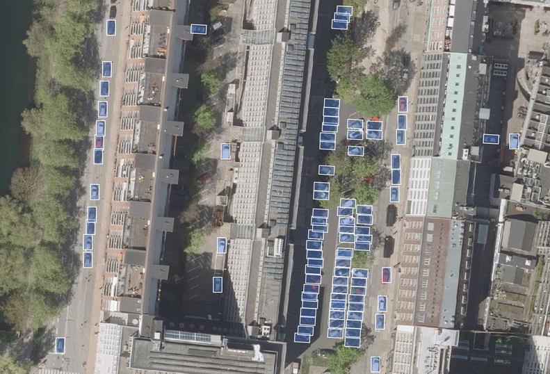
Locating solar panels on rooftops using Deep Learning.
Tracking cars in urban areas with Region-based Convolutional Neural Network (R-CNNs).
Powerful new advancements
Modern Earth Observation holds great potential to bridge the gap between Remote Sensing and AI, and allows for users to gain insights like never before.
At DHI GRAS, we are intrigued by the developments we are seeing in this field.
We are working hard in our Deep Learning Lab to explore what is possible and inspire our clients to think in new ways. Our aim is to create awareness of how DL has the potential to significantly optimize existing workflows.
We welcome all ideas – so if you have an object you would like us to map, we can be reached at gras@dhigroup.com.
Authors: Philip Graae (phgr@dhigroup.com) & Kenneth Grogran (kegr@dhigroup.com)